Nui Chua : baies et collines arides
Phan Rang · Vinh Hy · Binh Tien · Cam Ranh
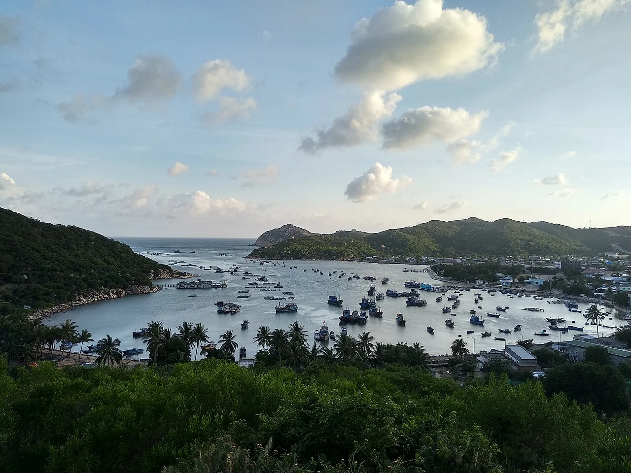
Photo de région ou transport, pas un arrêt garanti. ©
Use a full day for this one-way coastal link, with Vinh Hy as a natural rest point. Dry hills and sheltered bays alternate, inviting short walks where safe parking exists.
The driest ground in the country
Ninh Thuận was folded into Khánh Hòa in June 2025, but the weather did not notice the paperwork. The plain around Phan Rang is the driest centre in Vietnam: average rainfall under 700 mm a year, and in some years under 500. The scientific case made for Núi Chúa counted nine dry months, four arid ones and two of extreme drought in the annual cycle — an index written as X = 9.4.2 — and put this stretch of coast at the top of the country's list for aridity. The reason is geometry. Rings of mountains to the north, west and south screen the plain from both monsoons: the north-east monsoon brings little moisture here, and the south-west monsoon has already dropped most of its water on the higher ground inland, reaching the coast only at the end of its season. Núi Chúa itself does slightly better than the plain, close to 1,000 mm against 650–750 at Phan Rang and Mũi Dinh. The hills you ride past are thorn scrub, not forest, and that scrub is the point of the place rather than evidence that something went wrong.
A turtle crawling out of the sea
Núi Chúa National Park was created on 9 July 2003 by prime-ministerial decision 134/2003/QĐ-TTg, out of a nature reserve that had been protecting dry forest since the 1990s. On 14 April 2021 UNESCO added it to the world network of biosphere reserves, 106,600 hectares of it, in the same round as Kon Hà Nừng. The park proper is 24,353 hectares — 16,087 under strict protection, 8,261 under rehabilitation, five for the offices — with an 11,200-hectare buffer zone, and a marine protected area of 7,352 hectares alongside. It sits on a promontory with water on three sides: the lower part of Cam Ranh bay to the north, the East Sea to the east and south, the Đầm Nại lagoon at the southern foot, and Highway 1 as the western edge. Vietnamese geographers like to point out that from a satellite the massif looks like a turtle with its head turned south and its tail — the Mũi Xốp headland — poking into the mouth of Cam Ranh bay. It measures about 33 kilometres north to south, carries 57 kilometres of coast, and tops out at 1,039 metres on Cô Tuy.
Eleven kinds of turtle
The turtle shape is a coincidence; the turtles are not. Núi Chúa holds eleven species of turtle, land and sea, more than any other special-use forest in Vietnam, and several of its beaches are the last nesting sites left on the Vietnamese mainland for small numbers of endangered green turtles. Offshore, surveys have recorded 307 coral species on the fringing reefs, in good to excellent condition and with a community structure unlike anything else on this coast; a WWF survey added 46 species new to Vietnam's records. On land there are 72 mammal and 181 bird species, including what is reported to be the country's largest known population of black-shanked douc. None of this is fenced off from people. About 30,000 live inside the park boundary and another 25,000 in the buffer zone — Kinh, Chăm and Raglai, the Raglai making up 21 per cent of the community. Their position is hard: households inside the park average six months of food shortage a year, and a large share of income has come from forest products taken illegally. Ride through knowing that, and spend your money locally.
Vĩnh Hy, which used to be Vũng Găng
Vĩnh Hy is a small bay shut in by mountains on the east, west and north with its mouth to the south, 42 kilometres north of Phan Rang and 43 south of Cam Ranh, with the Lồ Ồ stream coming down off Núi Chúa into it all year round. Because it is sheltered, the water stays calm when the open coast is not, and boats have always run in here ahead of a storm. The elders' account is that the first inhabitants were people from Quảng Nam, Quảng Ngãi, Quảng Bình and Phú Yên who came south with the Nguyễn lords in the eighteenth century on ghe bầu junks, put in to wait out weather, and stayed for the scenery and for the fresh water off the mountain. They called the village Vũng Găng; the present name, Vĩnh Hy, is a wish for busy trade and a peaceful, lasting life. The Ministry of Culture, Sports and Tourism ranked the bay a national scenic monument on 7 January 2020. The fishing has not stopped: grouper, red snapper, mackerel, tuna, shrimp, swimming crab and squid all come out of this water.
The bay at the end of the road
North of Vĩnh Hy the road climbs into the park and drops again to Bình Tiên, and after that the coast belongs to Cam Ranh. That bay is usually called the best deep-water anchorage in South-East Asia, and its history reads as a list of other people's navies: a French base in Indochina, a stop for the Russian imperial fleet in 1905 on its way to Tsushima, a Japanese staging point for the attack on Malaya in 1942, an American and South Vietnamese base during the war, then a Soviet Pacific Fleet base on a 25-year lease signed in 1978. Russia inherited the agreement, Vietnam eventually asked 200 million dollars a year for it, and on 2 May 2002 the Russian flag came down at Cam Ranh for the last time. The port is civilian now: Cam Ranh International Port opened on 8 March 2016, handles ships of 110,000 deadweight tonnes, holds eighteen at a time and 185 a year, and was the first in Vietnam designed to keep them moored through a force-eight storm.
C’est nous qui menons ce voyage.
Le guide fait partie de notre équipe, nous avons parcouru l’itinéraire nous-mêmes, et vous avez une seule conversation avec nous pour tout le voyage.
- Des guides de notre équipe
- Des itinéraires que nous avons parcourus nous-mêmes
- Notre atelier dans 5 villes et des ateliers partenaires
- Une seule conversation avec nous pour tout le voyage
- 16
- villes
- 24
- circuits
- 71
- itinéraires
- 6
- ateliers