Huế: những cung đường đầm phá
Hue · Thuan An · Tam Giang lagoon · Hue
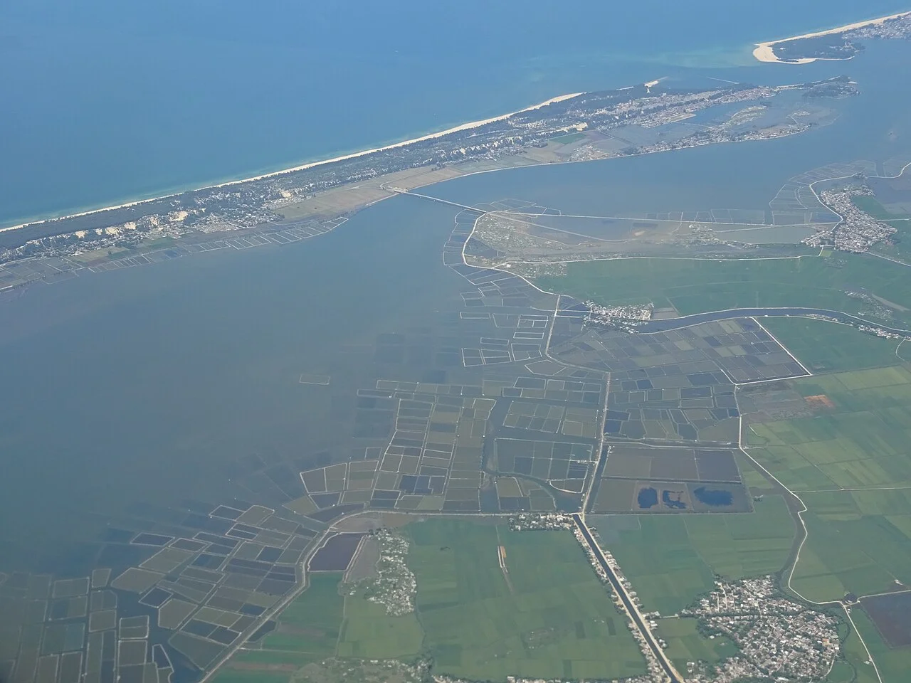
Ảnh minh họa vùng hoặc phương tiện, không phải điểm dừng cam kết. ©
Trade another monument day for the low coastal landscape. Ride to the sea, then linger by the lagoon with a lunch stop before returning to the city.
Sixty-eight kilometres of brackish water
Huế sits behind a lagoon, and once you have seen it on a map the city makes more sense. The Tam Giang – Cầu Hai system runs sixty-eight kilometres north-west to south-east along the coast with 216 square kilometres of water surface, and it is made of three parts. Phá Tam Giang is the northern one: about fifty-two square kilometres, twenty-four kilometres long from the mouth of the Ô Lâu to the mouth of the Hương, two to four metres deep and seven in places, and roughly eleven per cent of all the coastal lagoon water in Vietnam. Below it the Thủy Tú section — the basins called An Truyền, Thanh Lam, Hà Trung and Thủy Tú — runs another thirty-three kilometres. At the southern end Đầm Cầu Hai opens into a shallow half-moon basin of 11,200 hectares averaging one metre forty deep. The whole thing holds between three and five hundred million cubic metres of water in the dry season and up to six hundred million in flood, which is the real reason the plain behind it floods slowly rather than all at once.
The mouths move
The lagoon's openings to the sea are not fixed features; they are events. A historic flood in 1404 tore a second mouth open near the village of Hòa Duân, and it stayed open for five hundred years. In a storm surge on 15 October 1897 the water scoured a channel through the low dunes at Thai Dương Hạ into a new opening people called Cửa Sứt; it silted up, and then the storm of 19 September 1904 reopened and widened it into the mouth that is called Thuận An today. In the same storm Hòa Duân closed for good. In the great flood of 2 November 1999 the system punched out three at once — Hòa Duân again, Vinh Hải, and a new Tư Hiền — and a dam was put across Hòa Duân the following year. Tư Hiền itself is the ancient one, possibly opened three and a half thousand years ago, and it has been called Ô Long, Tư Dung and Tư Khách in its time. In 1811 a flood cut a second Tư Hiền three kilometres north of the first, and the two have been opening and closing in alternation ever since. Two mouths are working now.
Afraid of Tam Giang
For centuries the lagoon, the Thuận An mouth and the Perfume river together made the main water road up to the imperial capital, which meant that anyone going to the capital had to cross Tam Giang. It is only a lagoon, but it makes waves, and the folk verse about the road to Huế ends with a man admitting what stops him: fear of the Nhà Hồ pass and fear of phá Tam Giang. Where the rivers meet and the sea mouth narrows, the water turned and boats went over. The official Nguyễn Khoa Đăng eventually had soldiers widen the mouth and dredge the bed, and the accidents fell away. The fear stayed in the language. In the 1970s Trần Thiện Thanh set a poem by Tô Thùy Yên to music as An Afternoon on Tam Giang, and it is still the song people quote when they see this water for the first time. What actually happens on it now is quieter: floating markets that start at four in the morning and are gone by six or seven, selling what came out of the lagoon overnight and nothing else.
The pagoda on Túy Vân
At the far end, on a sixty-metre hill right on the shore of Đầm Cầu Hai, stands the one building on this route worth crossing the whole lagoon for. Lord Nguyễn Phúc Tần founded a pagoda here in the seventeenth century to pray for the people of the district; Nguyễn Phúc Chu had it regilded in the spring of 1692; war destroyed it in the second half of the eighteenth century. In 1825, on a progress down to the Tư Hiền mouth, Minh Mạng renamed the hill and rebuilt the pagoda, and in 1836 he rebuilt it completely, adding the Đại Từ pavilion halfway up and the three-storey Điều Ngự tower, about fifteen metres high, on the summit, and giving it the name Thánh Duyên. Under Thiệu Trị the hill was renamed again — the old name clashed with the personal name of the Empress Dowager — and local speech wore Thúy Vân into Túy Vân. Thiệu Trị ranked the hill and its pagoda ninth of the twenty scenes of the capital, and had the view painted onto enamelled porcelain with four lines of his own poem. It was a state pagoda, alongside Thiên Mụ. Today it is badly decayed.
How the day works
One long day, about a hundred and twenty kilometres, and almost no climbing. Out of Huế on Highway 49 to Thuận An, thirteen kilometres, then north-west to the Tam Giang bridge — the Ca Cút, 607 metres on thirteen spans, opened in March 2010, and still the only bridge across this lagoon. Then turn round and ride the sand bar south-east on Highway 49B with the sea on your left and the lagoon on your right the whole way: the bar is between two hundred metres and five kilometres wide and rises from two metres to thirty. At the end, Túy Vân hill, the Tư Hiền mouth and the bridge across it, and then home on the inland side past Cầu Hai. Three things to plan for. It is hot — the annual mean here is 25.2 degrees and June and July have touched 41.3. There is very little shade on the bar. And the names have all changed: on 1 July 2025 Thuận An absorbed Phú Thuận and Phú Hải, and Vinh Hiền, where the pagoda is, was merged with three neighbours into a commune called Vinh Lộc.
Chúng tôi tự dẫn chuyến đi này.
Hướng dẫn viên thuộc đội của chúng tôi, tuyến đường chúng tôi đã tự chạy, và bạn có một kênh trò chuyện với chúng tôi suốt chuyến đi.
- Hướng dẫn viên từ đội của chúng tôi
- Những tuyến đường chúng tôi đã tự chạy
- Xưởng của chúng tôi tại 5 thành phố và các xưởng đối tác
- Một kênh trò chuyện với chúng tôi suốt chuyến đi
- 16
- thành phố
- 24
- tour
- 71
- hành trình
- 6
- xưởng